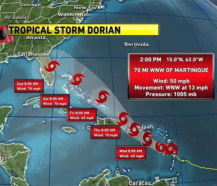
Tropical Storm Dorian Gaining Power
8/27/2019 (Permalink)
The latest Tropical Storm Dorian update from the National Hurricane Center features some potentially encouraging news for Floridians.
A still-uncertain long-term track showed the storm near Florida over the weekend, but Hurricane Hunters couldn't find a clear center during their latest flight due to the storm moving across St. Lucia. That disruption and dry air have kept Dorian from intensifying.
The storm's effects are expected to be felt in Puerto Rico by Wednesday afternoon and travel up to Hispaniola that night. Forecasters say Dorian will then head toward the Bahamas Friday and Saturday and reach southeastern Florida by early Sunday.
While uncertainty is high, Florida residents should monitor the progress of Dorian and ensure that they have their hurricane plan in place.
There was a slight adjustment north in the forecast cone Monday night to include Orlando and Daytona Beach. The cone was also tightened up to cross the eastern side of Hispaniola, meaning it is less likely now that the mountains will have a chance to significantly weaken Dorian.
If the storm goes across the Dominican Republic and Haiti, the mountains might weaken it, but if it stays over the ocean, weather officials believe the storm could gain strength as it travels towards Florida.
The U.S. National Hurricane Center said that as of 11 a.m. Tuesday the storm has maximum sustained winds near 50 miles per hour and is forecast to strengthen during the next 48 hours before hitting the U.S. territory. It is currently 60 miles west-northwest of St. Lucia.
We're in the peak of hurricane season
Dorian is the fourth named storm of this hurricane season. Generally, the season reaches a peak in the eight weeks surrounding September 10.
Two-thirds of all the storms produced in a typical season occur during this period.
That's because conditions in the tropics become ideal for storm development. By the end of August, water has typically warmed to the mid-80s in many parts of the region.


 24/7 Emergency Service